<HTML>
<HEAD>
<TITLE>SaVi</TITLE>
<!-- Copyright (c) 1996 by The Geometry Center. All Rights Reserved. -->
</HEAD>
<BODY BGCOLOR="FFFFFF">
<!-- *Navigation-Links -->
<B>Next:</B> <A HREF="orrery.html"><I>Orrery</I></A><BR>
<B>Up:</B> <A HREF="./"><I>Geometry Center Visualization and Simulation Software</I></A><BR>
<HR>
<p>

<!-- *Begin-Document-Body -->
<CENTER>
<H1>SaVi</H1>
</CENTER>

SaVi is a program for the visualization and analysis of satellite
constellations.  It provides for the specification and tracking of an
arbitrary number of earth-orbiting satellites.  Satellite orbit
parameters can be dynamically changed at any time during the orbit
simulation.

<p>

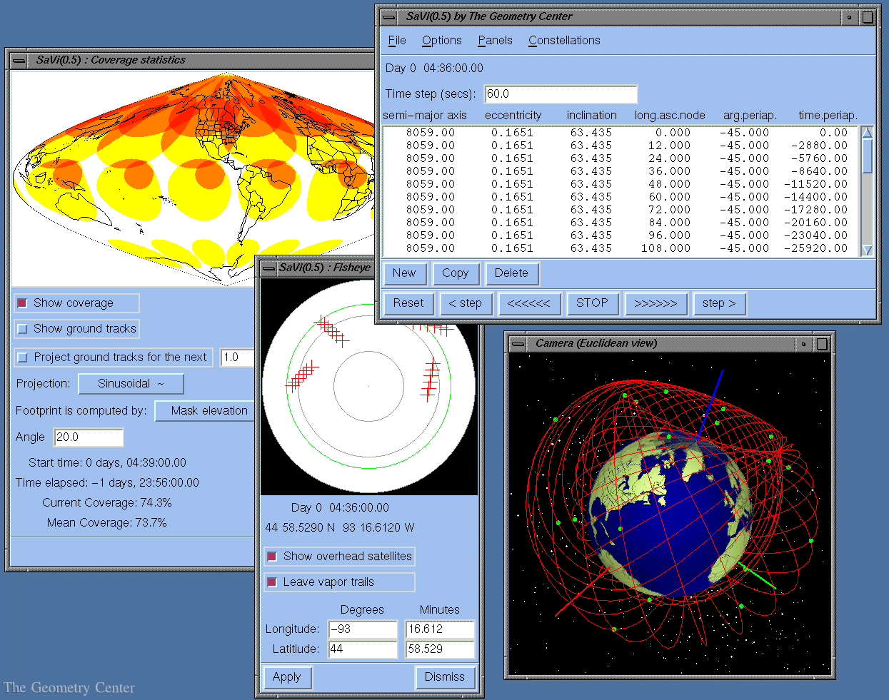
SaVi uses Geomview to display a 3D view of the earth in which each
satellite is represented by a small green box.  The Coverage panel
shows a color-coded image of satellite footprints, and tracks their
evolution during the orbit simulation.  The Overhead View panel is
that of an observer looking up from a specific point on the surface of
the Earth. The apparent positions of the satellites are traced across
the observer's sky, which is projected "fisheye" style onto the panel.

<p>

<CENTER>
<A HREF="savi-big.gif"><IMG SRC="savi.gif"></A>
</CENTER>
<p>

SaVi is currently under development; future developments will be
motivated by the needs of the community.  For futher information, see
the <A HREF="/locate/SaVi">SaVi home page</A>.
<!-- *End-Document-Body -->
<p>

<!-- *Navigation-Links -->
<HR>
<B>Next:</B> <A HREF="orrery.html"><I>Orrery</I></A><BR>
<B>Up:</B> <A HREF="./"><I>Geometry Center Visualization and Simulation Software</I></A><BR>

<!-- *GC-Common-Footer -->
<HR>
<NOBR><A HREF="/"><IMG SRC="/pix/home.gif" ALT="[HOME]" ALIGN=MIDDLE></A>
<I>The Geometry Center Home Page</I></NOBR>
<p>
Comments to:
<A HREF="/admin/mail/webmaster.html">webmaster@geom.umn.edu</A><BR>
Created:  Oct 01 1996 --- 
<!-- hhmts start -->
Last modified: Dec 18 1996
<!-- hhmts end -->
</BODY>
</HTML>
